The mission of East Bay Trails.com is to showcase trails and nature in the San Francisco East Bay and around the world. I believe the path to health and wellness lies in exploring nature, especially through hiking. Through photography, video, news and information, my goal is to share what I've seen so that people become motivated to explore nature, and through that effort, become healthier.
Deer watching sunrise, Pt. Reyes National Seashore
Thank you for visiting East Bay Trails. I've transitioned to a new platform and a new site. The new site is called "Find Your Trail," which better reflects the more geographically diverse spectrum of trails I'll be visiting.
I will leave East Bay Trails.com active, for those who care to use it. I've transferred all of this content to the new site. If I've missed anything, please let me know.
The Twin Ponds loop is a nice dawn hike, and an even better run. It's a short 2.4 mile loop that takes you through classic Northern California landscape of rolling hills, canyons and twisted oaks.
Please be respectful of the residents if you get there early in the morning. There is street parking only in this residential area.
Go through the gate and bear right. I took the lower loop trail on the right.
Walk through a beautiful oak grove...rolling, oak covered hills are on your right, a dry canyon bed is on the left. In the rainy season, this won't be so dry.
The oaks were changing color in the late fall.
.12 Keep left at split
Until you get to Bullfrog Pond, you'll be on a single track trail with a slight incline. Although no bikes are allowed, 5 bikers came barreling down this trail at dawn. They saw me but didn't slow down, so pay attention when you're out there.
Early morning light hits a grove of oaks at the top of the hillThis big oak reaches out to hikers on the trail
.61 miles, take a left on to the marked Twin Ponds Trail. Bullfrog Pond (dried up at this point) is on the right.
Keep right after pond and continue.
.71 miles keep straight on Twin Ponds Loop Trail. This is also marked.
.76 miles, keep left at split. (Taking the other trail is a short detour).
.80 Nice bench
If you sit here at dawn, while the sun rises, you can feel the warmth of the sun on your back as you listen to the birds.
.93 Keep Right at split
1.08 Another beautiful bench
1.18 Continue through beautiful Oak forest
1.40 Left on to Twin Ponds Loop Trail...Pond is on your right...Go left past bench
1.83 Cross Bridge
2.08 Keep left
2.15 Trail splits...Left is wide trail, but you go right, on to single track in to the Oak forest. This will take you back to the trailhead.
2.40 Finish
Total mileage was 2.40 miles. There are numerous side trails that can take you follow all the way to Mt. Diablo State Park. This hike is in Walnut Creek Open Space. Be prepared and enjoy your hike!
Roberts Regional Recreation Area is a beautiful place to hike and relax. Just off the main parking area, to the right as you drive in, is a monument to the Japanese Veterans of World War II. It's a peaceful location to reflect on the sacrifices so many have made so we can live our lives in peace and relative tranquility. To all our veterans, especially you Dad, thank you for all you have done for our country.
The plaque says: "Dedicated on August 7, 1992 by E Company veterans of the 442nd regimental combat team, the most decorated United States Army unit of WW II. The all volunteer 442nd regimental combat team was composed of Americans of Japanese ancestry, from the territory of Hawaii, and the United States, many that volunteered from American concentration camps, in to which these citizens had been forcefully evacuated by the United States government in 1942."
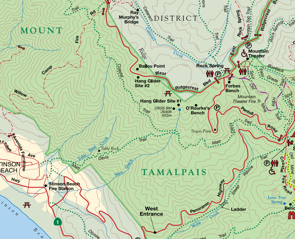
Marin is a great place for hikers, and Mt. Tamalpias is loaded with good hikes. I expect to be here more as the rains start. The streams here and in the Marin Water District lands are beautiful and abundant.
From the Pantoll Ranger station, I took the Matt Davis Trail. The trail goes all the way to Stinson Beach, and also connects to the Coastal Trail. If you park at the ranger station lot, you'll pay a parking fee (currently $8). There is also a smaller lot above, but the gates close at sunset.
There is a sign marking the start of the Matt Davis Trail.
Starting out on the Matt Davis Trail, you'll pass a bench and traverse a hillside before you enter the canopy.
I visited this trail twice. On my first trip, the light was just terrible for photography. I still took pictures, but decided to come back and see this place in better light. I came back a week later, this time in late afternoon. In the following images, the late afternoon light better illuminates the leaves and foliage, and shows off more of the tree structure.
The trail is well constructed, braces and bridges seem solid.
This is a beautiful trail, with a nice variety of trees and foliage. Moss and lichen are abundant, and the moss becomes especially vibrant after rains.
Keep an eye out for this Madrone reaching out to grab unwary hikers...
Notice, as you hike, the structure and variety of the trees on the hills above and below you. You can sense the community of nature as you hike through the mossy Bay trees and twisted, majestic Oaks.
The whip will keep you moving along on your hike.
This trail will change dramatically during the rainy season. If you visit in the winter, after a few heavy rains, the hillsides will be running with little streams and feeder creeks.
Sometimes, when I hike, I get the feeling I'm being watched...
You'll see this guy up on the hillside.
At 1.6 miles, the trail splits as you come out of the canopy. The upper trail is the Coastal Trail, the lower one is the Matt Davis Trail.
Upper trail leads to Bolinas-Fairfax Road. Lower trail is the Matt Davis trail to Stinson Beach.
Hiker up on the Coastal Trail
Hikers on the Matt Davis Trail
I took the Matt Davis trail, and my goal was to hike to a lookout spot not long after the split. When you see this trail marker, look to your left. Climbing up on to that trail will take you to the lookout spot.
You'll climb up a little hill, and then you'll see the Cypress off in the distance.
The lookout point is past the Cypress
The curious hawks, turkey vultures and other birds might come over to check you out. Even with my wide angle landscape lens, this guy came close enough for me to take his picture. Maybe that was his intent...
As you face the ocean, look to your left. Off in the distance, beyond the hills, you can see San Francisco and the Golden Gate Bridge.
This beautiful but bruised Oak is just off the trail. Be gentle and don't climb on it.
There is a nice view as you look back to the hills and the forest. The canopy is off to the right. To return back to the trail head, follow the spur back to the Matt Davis Trail and take a right. If you want to go all the way to Stinson beach, go left.
I turned right and back in to the forest as the warm late afternoon light faded.
Even late in the fall there was a trickle of water running in this stream bed, making the surrounding foliage more lush and vibrant.
The trail looked quite different on the return direction. Watch for toothy roots that might grab your ankle and not let go, or maybe just try to trip you...
At the end of this hike, I didn't want to leave the trail. I watched the setting sun light up the moss on these trees, right off the trailhead.
The Pantoll ranger station is a bit of a drive to reach, but offers acccess to a variety of trails. The road leading there is twisty and steep, but this area is worth multiple visits.
The trailhead has parking, but it's limited. There are maps, but no other facilities. Starting out at the trailhead, the trail I took was an out and back visit to the Madrone grove on the northeast part of the trail.
At the trailhead
One of the nice things about hiking in the fall is that the poison oak turns red, and becomes easier to identify. This trail has a lot of poison oak along the edges, so if you bring your dogs, make sure you wash them after the hike. They can pick up the oils on their coat and the oils can spread to you when you pet them.
This trail is loaded with structurally beautiful trees, especially oaks. Many of these trees are well over one hundred years old.
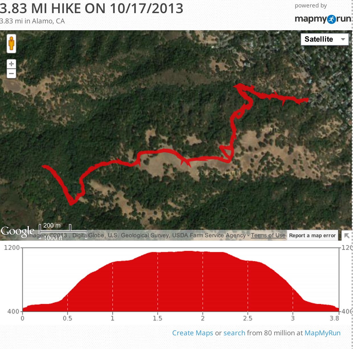
The initial part of the hike starts out with a reasonable climb. It will get your heart beating. I started the hike in the late afternoon. My goal was to photograph the trail and forest as the sun was setting.
The hike starts out on Ringtail Cat Trail. At .32 miles, you'll come to a split. The trail to your right is a dead end that takes you to South Ave. Continue left and keep climbing on the Ringtail Cat trail. In many places along this hike, there are unmarked trails that branch off the main trail. Some seem to be bike trails, others are either steep climbs or switch backs. Stay on the main trail as it climbs to Madrone Trail.
The setting sun illuminates the leaves.
Continue the climb and keep to your right. The trail continues .95 miles from the previous split. The Oaks in this area are beautiful, and the sun was setting as I climbed higher.
The setting sun lights up the background trees.
I passed several hikers with dogs, and when I reached the Madrone Trail, I saw a biker ride by with his dogs. There were a lot of cows in the area. East Bay Regional Parks allows grazing to keep grasses down and minimize the risk of fire.
The cows will move out of your way.
A cow licks salt as the setting sun illuminates her.
As you hike, look to the hillsides around you to see some beautiful trees and groves. This is what the whole area looked like a few hundred years ago.
At about 1.27 miles, you'll come to the Madrone Trail. Bearing left can take you to the Eugene O'Neill National Historic Site. I continued right, heading Northwest on the Madrone Trail. The trail continues to climb, and you'll see some nice views of the valley below.
The trail widens and continues, and you might see a few more cows as you make your way to the Madrone grove.
Look for this beautiful Oak as you approach the Madrone Grove.
You'll reach the Madrone Grove at about 2 miles, and you'll see these trees scattered about in the forest. The light was good to capture their unique beauty. These trees are found only in the western US and Canada. From the Wikipedia entry:
Arbutus menziesii is an evergreen tree with rich orange-red bark that when mature naturally peels away in thin sheets, leaving a greenish, silvery appearance that has a satin sheen and smoothness. The exposed wood sometimes feels cool to the touch. In spring, it bears sprays of small bell-like flowers, and in autumn, red berries.Native Americans ate the berries, but because the berries have a high tannin content and are thus astringent, they more often chewed them or made them into a cider. They also used the berries to make necklaces and other decorations, and as bait for fishing. Bark and leaves were used to treat stomach aches, cramps, skin ailments, and sore throats. The bark was often made into a tea to be drunk for these medicinal purposes.
Madrone Tree
Madrone along the trail.
Another Madrone is lit beautifully by the setting sun.
The plaque says: This Madrone Grove is dedicated to Mary Rogers Smith, for her effort in preserving these hills and woods. We owe a debt of gratitude to people like Mary Smith. I didn't know her, but I'm very grateful for her efforts to protect and preserve this resource for all of us.
You'll see this memorial to Mary Smith at the 2 mile point.
I turned around at this point, since the sun was starting to fade. If you have time and energy, you can take a mighty loop hike that includes the Las Trampas Ridge Trail and the Corduroy Trail. See the trail map for more details.
Watching the setting sun light up the valley below was a great experience.
Once the sun set, the temperature dropped quickly. The dull light and shadows accented the dramatic structure of the trees.
This last image was taken in near darkness. Hiking at dusk is interesting but potentially risky, so make sure you bring a flashlight.
My total mileage was 3.83 miles. The climb up was certainly more challenging than the descent, and the elevation chart is below.
There were a lot of cows on this trail, and I know some people are wary of them. I've never had a bad experience with cows, but give them room and don't startle them. All they want is to eat and be left alone.
This is a beautiful and heart building hike that can lead to a variety of other trails and routes. Plan ahead, bring water, and enjoy the experience!

 Deer watching sunrise, Pt. Reyes National Seashore
 East Bay Trails